http://www.africamuseum.be/home/treasures/ortelius_map_sept17
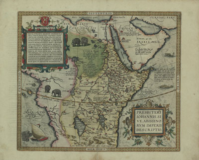
Map of the Empire of Prester John, or of the Abyssinians
Ortelius was the first cartographer to include regional maps of Africa in his atlas. A notable example is this map of Abyssinia added in the Latin edition of 1573. It represents the empire of the legendary Christian king Prester John whose genealogy and regal titles are developed in a cartouche in the upper left, together with a description of his area of jurisdiction.
For the first time we see the two Ptolemaic lakes named on our maps: the western lake has the double name of Zaire lacus and Zembre lacus, and the eastern lake is called Zaflan lacus, both feeding the Nile. In the centre of the western lake Ortelius indicates that there are Tritons and Sirens, and on its eastern shores Amazons are supposed to live, part of the imaginary population of the still totally unknown interior. To the north is the Niger lacus acting as the source of the north- and west flowing Niger river. Also copied is the distinct hydrography of the Congo region, albeit without the link to the western lake.
There are, however, a few features which clearly differ from other maps on Central Africa.The west-east width south of the equator is significantly reduced, the westernPtolemaic lake no longer feeds the Zambezi/Limpopo rivers, nor the Zaire river,and the Mountains of the Moon (Lunae montes) are prominently shown, with theindication that beyond them to the south, Africa was unknown to the ancients.The island of Zanzibar is not on the map. Besides, this is the only one of hisregional maps of Africa (apart from the small plan of Carthage) not to have a graduated border. We are left in the dark as to why this should be so, as Ortelius offers no explanation for these manifest geographical incoherences.
Since the text on the verso of the map is mainly devoted to Prester John’s empire and its inhabitants, Ortelius provides some supplementary legends on the map itself. Nubia, it says in the centre, was once a Christian kingdom but no longer adheres to any religion. It has gold and ivory in abundance which is traded in its capital Dangala on the Nile. A mountain range just north of the Equator is identified as the place where the sons of Prester John are held captive. These legends help to fill some of the empty spaces to the west of the Nile, as much as the two groups of elephants which, we may note in passing, resemble more the Asian type than the African genus, on account of their relatively small ears.
This map is enclosed in the recently publication of the RMCA by Wulf Bodenstein, Exploring Africa with Ancient Maps, Tervuren, 2017.