This topic will gather information aiming at a live cartography of Brussels air traffic, there are several existing flight maps such as flight radar but those live maps are not associated to comprehensive information about flight consumption for example.
Resistance again the construction of new airports is important in most places in Brussels also as it is said to be the most noise-polluting airport of 30 European airports in terms of the number of people affected by take-off and landing operations. see le soir magazine article
We would like to contribute to a larger conversation by proposing a flight map that would also serve as an information platform about the functioning of contemporary commercial transportation system and its relation to fosil fuel
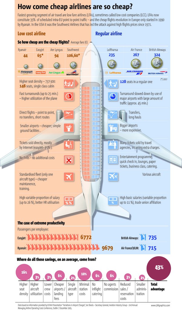
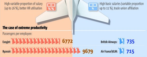
At first sight it seems quite rational and a good use of resources. But then, you start looking at the details, e.g., how low-cost companies compare regarding ‘Human Resources’:
Low-cost companies are said to have “better HR utilisation”, with a variable part of employee’s salary that reaches up to 1/4, and no trade unions; oh, and low-cost companies’ employees need to handle 10 times more passengers per employee. Pilots may be better paid, but they stop only for 25 minutes against 45 minutes for a regular company. And, ahem, low-cost companies are actively seeking to reduce weight at all cost!
On the other side it seems that trains are managed in an absurd manner for example in F̷̪̤̋ṟ̵͙̾͗a̷̛̩̎n̴͙͙̿́c̸̙͙̈e̵̪͒ it management of train bookings are so absurd that they would not do it differently if they wanted to rise absurdly the ticket prices. However one of the main post of spending is maintenance of the tracks 30% of ticket cost while obviously the maintenance of the roads is not paid for by the cars/truck drivers here is the last sncf financial report
Other example also airports benefit from public funding 2 million Euro for the construction of the new low-cost terminal in Lyon